Resources
Why 2026 Severe Storm Losses Are Set Before the Storm Forms
Severe storm losses don't begin when a storm materializes. They're shaped earlier — by underwriting and renewal decisions, by the quality of underlying property data, and by how risk accumulates across a portfolio over time. A new ZestyAI on-demand session, featuring Robert Silva, ACAS (formerly Farmers Insurance) and Keren Chheang, FCAS (formerly Wawanesa), examines the upstream patterns driving 2026 severe convective storm (SCS) outcomes — and where traditional CAT models are diverging most sharply from realized loss.
About this session: Loss Happens Before the Storm: The New Drivers of 2026 Severe Storm Risk is an on-demand webinar covering why storm losses vary dramatically within the same ZIP code, what three record SCS years (2023: $66B, 2024: $59B, 2025: $51B) reveal about portfolio volatility, and the underwriting and pricing decisions carriers are making now. Featuring Robert Silva, ACAS, and Keren Chheang, FCAS.
Prefer to watch instead? Access the full on-demand session → — includes property-level signals, CAT model gaps, and live Q&A.
When are 2026 severe storm losses actually being set?
Earlier than most carriers price for. Once a storm forms, the loss outcome on any given property is largely determined by conditions that were locked in months or years before: roof age and condition, the property characteristics the carrier underwrote on (or didn't), the renewal decision made at the last anniversary, and the aggregate exposure the portfolio quietly accumulated through prior cycles. The storm is the trigger. The loss was already set up.
That's the framing shift behind this session. Carriers that treat storm season as the moment exposure crystallizes consistently arrive too late to influence the loss outcome.
Why are traditional CAT models misaligned with realized loss?
Because the gaps that drive loss aren't event-driven, they're data-driven. Traditional CAT models work at a level of geographic and structural abstraction that smooths over property-level variability — roof age, prior weathering, soft-metal exposure, structural state. When the building stock is uniform, that abstraction works. When it isn't — and three record years of accumulated damage mean it isn't — the modeled loss and the realized loss diverge. Carriers feel this as adverse surprise in seasons the model didn't flag.
What upstream decisions actually drive portfolio-level storm outcomes?
Four levers, in roughly the order they take effect:
- Underwriting data quality. The accuracy, coverage, and consistency of property-level information at the point of underwriting sets the ceiling for every downstream decision.
- Rating and segmentation choices. Whether structural signals — roof age, condition, prior loss exposure — are priced into the rate, or smoothed into a territory average.
- Renewal decisions. Whether deteriorating properties are repriced, repositioned, or non-renewed before the next season, or carried at the prior year's terms.
- Portfolio accumulation. Whether risk is concentrating in degraded properties or in better-conditioned ones across the book.
Each of these decisions happens long before a storm forms. Each shapes how much loss any future storm will produce.
How do property-level signals change underwriting and renewal decisions?
Property-level signals — roof condition, accumulated weathering, prior structural exposure — let carriers segment risk before it shows up as a claim. The session walks through how carriers are using this layer of intelligence to inform underwriting decisions, calibrate rating plans against structural realities the territory map can't see, and identify properties that quietly migrated from "acceptable" to "deteriorated" since the last renewal. The point isn't to write less business. It's to know which business is changing before the storm reveals it.
What this means for 2026 storm strategy
As the 2026 season takes shape, many of the loss outcomes carriers will record this year are already being set — through underwriting decisions being made now, through renewal terms being finalized, through portfolio accumulation patterns that won't be visible until they show up as concentrated loss. The session is built for product, underwriting, pricing, portfolio, actuarial, CAT, and reinsurance teams shaping how their organization shows up before the first storm forms.
Watch the full session on demand
Loss Happens Before the Storm: The New Drivers of 2026 Severe Storm Risk →
Featuring Robert Silva, ACAS (formerly Farmers Insurance) and Keren Chheang, FCAS (formerly Wawanesa), the session goes deeper on CAT model divergence, the four upstream loss drivers, and what differentiated underwriting can move on 2026 portfolio outcomes.

ZestyAI Launches AI-Powered Property-Level Model to Predict $25B “Everyday Fire” Risk
ZestyAI today announced Z-SPARK™, an AI-powered model that predicts non-weather fire risk at the individual property level.
The model evaluates the factors that influence ignition and fire spread to help insurers identify the structures most likely to generate costly fire losses.
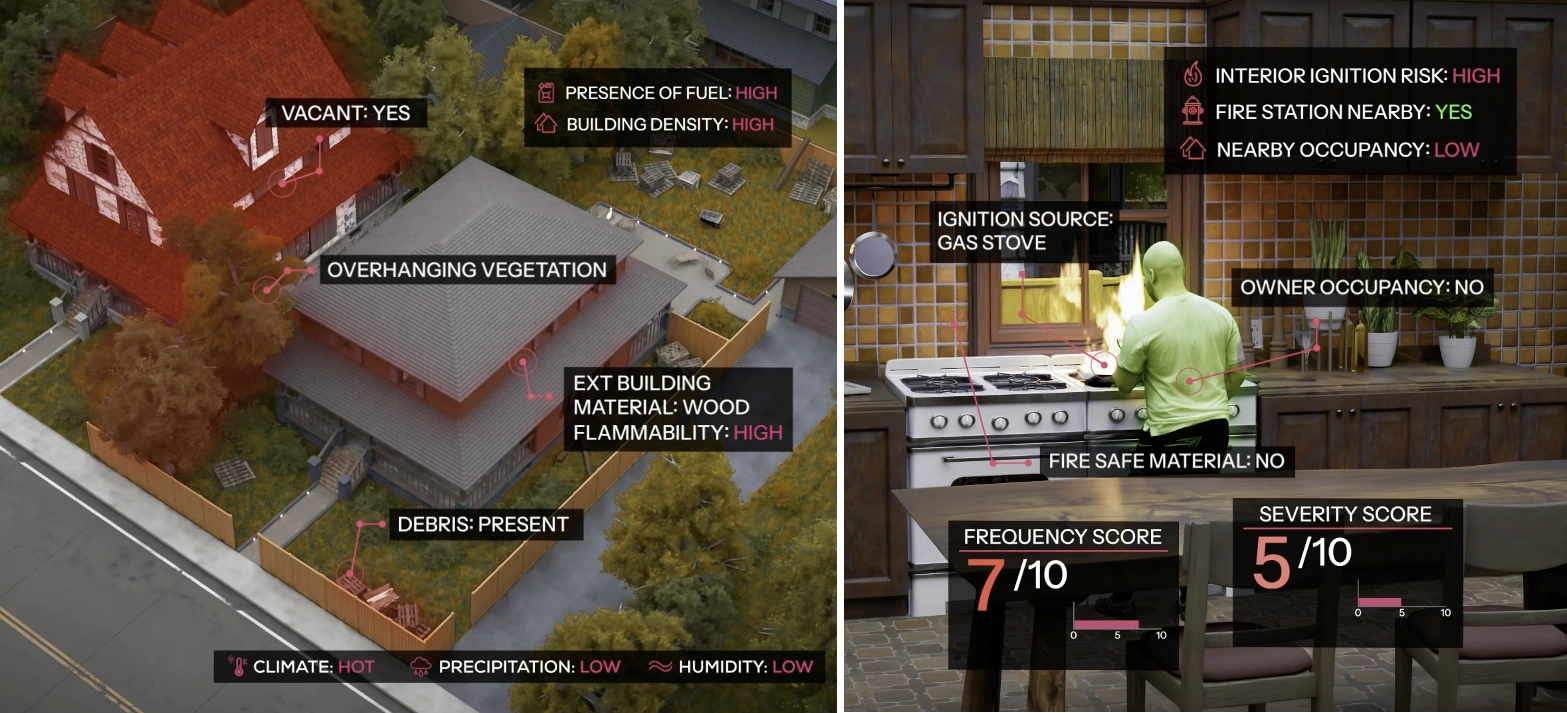
Most insurers still evaluate fire risk using neighborhood or territory level averages and limited historical loss data, even though risk can vary dramatically from one property to the next. Without property-level insight, insurers struggle to price risk accurately, increasing the likelihood of adverse selection and unexpected losses.
In 2023, $25 billion in property losses occurred from non-weather-related fire incidents from sources such as grills, appliances, heaters, and electrical faults.
Z-SPARK applies modern fire science and property-level intelligence to analyze how building materials, maintenance conditions, surrounding structures, local fire response capacity, and climate drive ignition and fire spread.
The model predicts both the probability of ignition and potential loss severity using advanced machine learning trained and validated on millions of real fire incidents and verified insurance claims.
With these insights, insurers can:
- Price with precision — align premiums with true property-level fire risk rather than broad geographic averages
- Streamline operations — support straight-through processing for low-risk properties
- Prioritize underwriting resources — focus manual review and inspections where risk warrants closer scrutiny
- Expand confidently — write business in challenging markets with a clearer view of actual exposure
- Protect portfolio performance — proactively manage concentration risk before losses accumulate
Z-SPARK delivers 30× greater risk differentiation than traditional territory-based models.
“Non-weather fire is one of the most costly and least understood risks in property insurance,” said Kumar Dhuvur, Founder and Chief Product Officer of ZestyAI.
“Two homes on the same street can have dramatically different fire risk depending on how they were built, maintained, and what surrounds them. Yet most insurers still evaluate that risk using community-level scores. Z-SPARK reveals those hidden differences so insurers can make decisions based on the actual risk at each property.”
ZestyAI’s Z-FIRE wildfire model is widely used by insurers to assess catastrophic wildfire exposure. Z-SPARK extends that expertise to everyday building fires, applying the same property-level intelligence to the most costly source of insurance loss.
Together with models for hail, wind, severe convective storms, and water damage, Z-SPARK expands ZestyAI's suite of AI-powered capabilities across the most costly perils affecting insurance portfolios. Combined with ZORRO Discover — which applies agentic AI to help insurers research markets, prepare filings, and act on risk intelligence faster — the ZestyAI platform gives insurers a comprehensive view of property-level risk and the tools to act on it across underwriting, pricing, and portfolio management.
American European Insurance Group Strengthens Multi-Peril Underwriting with ZestyAI
Insurer selects AI models for water, hail, and wind to drive disciplined growth and improve exposure management
ZestyAI today announced that American European Insurance Group (AEIG) has selected its suite of regulatory-approved AI models to enhance underwriting, pricing, and exposure management across its multi-state property portfolio.
Through the ZestyAI platform, AEIG has adopted models for non-weather water (Z-WATER™), hail (Z-HAIL™), and wind (Z-WIND™), along with Z-PROPERTY™ to deliver property-level risk insight.
ZestyAI’s models are built, trained, and validated on carrier-contributed loss data and analyze the interaction between property characteristics, environmental conditions, and peril behavior to predict claim frequency and severity at the individual property level. Carriers apply these insights at new business and renewal to sharpen risk selection, improve pricing alignment, and manage portfolio concentration. ZestyAI’s models have secured regulatory approvals that enable transparent and defensible use in underwriting and pricing.
“As we operate across states with varied exposure profiles, we need consistent, property-level insight into what drives losses across wind, hail, and non-weather water,” said Steve Hartman, President and CEO of AEIG.
“ZestyAI gives us the precision to align underwriting and pricing with expected loss performance, support our agent partners with greater transparency, and maintain disciplined growth. Corporate experience alone is no longer sufficient to intelligently compete in a crowded marketplace, and the ability to leverage both traditional and non-traditional data in best-in-class account underwriting and pricing is a requirement for sustained profitability.”
“Regional insurers like AEIG are balancing expansion with the need to stay highly disciplined in how they evaluate property risk,” said Attila Toth, Founder and CEO of ZestyAI.
“By grounding underwriting and pricing decisions in verified, property-level intelligence, AEIG can expand across diverse exposures with confidence while protecting portfolio performance.”
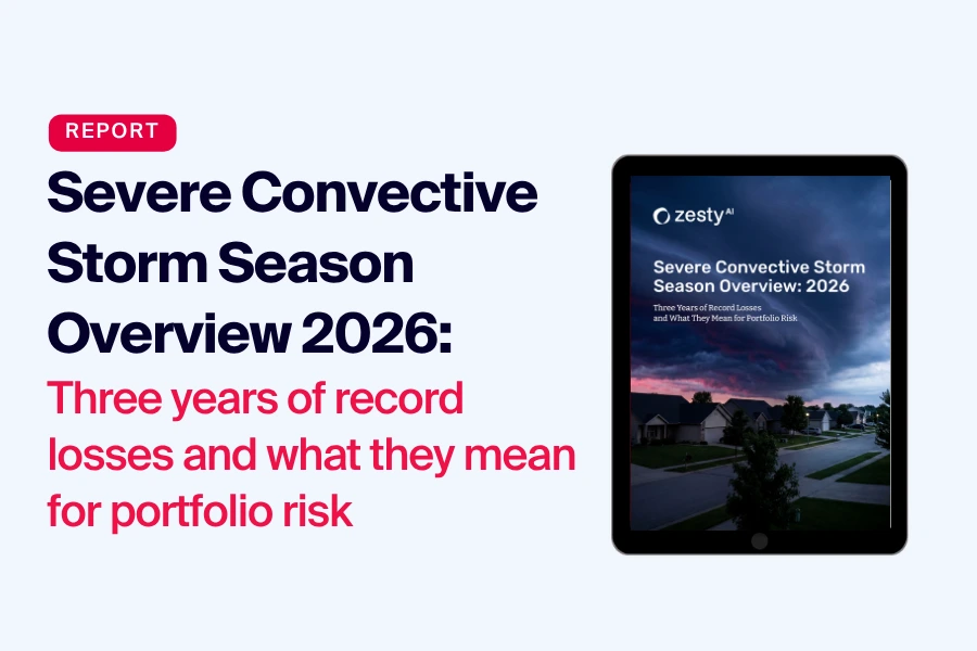
Why Severe Convective Storm Losses Now Depend More on Structure Than Geography
Three consecutive record years — $66B in insured losses in 2023, $59B in 2024, and $51B in 2025 — have reshaped how carriers need to think about severe convective storm risk. A new ZestyAI executive briefing on the 2026 SCS season shows the defining feature of these losses isn't storm frequency. It's accumulated structural damage. Within the same ZIP code, sometimes within the same complex, properties exposed to identical storms are producing materially different outcomes — and territory-level analysis is smoothing over the dispersion that actually drives the loss.
About this analysis. Findings are drawn from analysis of recent SCS seasons, IBHS research, and property-level storm segmentation across U.S. portfolios. The full briefing — 2026 Severe Convective Storm Season Overview — is a 16-page executive report covering loss dispersion patterns, peril-specific modeling, and what differentiated underwriting can actually move on portfolio performance.
Want the data? Download the full briefing → — 16 pages, immediate access.
What's driving three consecutive record SCS years?
Severe convective storm losses have accelerated steadily over the past five years, with sustained elevated activity beginning in 2020. The pattern of 2023, 2024, and 2025 — three of the highest insured-loss years on record back to back — isn't random. Underlying storm frequency has increased, but the cumulative effect on the building stock is the part most often underestimated. Each season of hail and wind exposure leaves a portfolio in a slightly more vulnerable state going into the next.
Why doesn't ZIP-code geography explain SCS loss patterns anymore?
Territory-level analysis smooths real differences between buildings. Two homes on the same street can face the same hailstorm and produce very different claims depending on roof age, roof material, prior exposure, defensible space, and the structural state of soft metals like gutters and vents. Blending those properties into a ZIP code average hides volatility that materially changes portfolio performance under stress.
That's the structural-not-geographic shift. Identical storms produce different outcomes because the structures aren't identical — and territory-level segmentation can't see it.
How does accumulated structural damage compound SCS risk?
This is the part of the story regulators and reinsurers are starting to focus on. Small hail events and ongoing weathering degrade roofing systems over time, even when no individual storm triggers a claim. Each marginal event leaves the roof slightly more vulnerable. Over a multi-year SCS cycle, the portfolios most exposed to losses are often the ones that quietly accumulated the most undamaged-but-degraded properties through prior seasons.
The implication is that a portfolio's SCS risk profile in 2026 isn't fully captured by its 2025 loss experience. The risk that didn't claim is still on the books.
Why does peril-specific modeling matter for hail and wind?
Hail, wind, and recurring micro-exposure don't behave the same way within an SCS footprint, even when they're all grouped under the same broad peril category. Hail damage concentrates in dense, often spatially clustered loss events. Straight-line wind produces a different damage signature. Recurring small-hail exposure compounds slowly across seasons. Modeling all three as a single SCS exposure obscures the separation that property-level intelligence can actually pick up — and that differentiated underwriting can actually act on.
What can property-level segmentation actually change?
In a Texas retrospective covered in the briefing, targeted underwriting actions informed by property-level segmentation would have reduced modeled loss cost by 48%. That's the magnitude of separation hiding inside portfolios that look uniform at the territory level. It's also what makes the 2026 question simpler than it sounds: not whether storms will develop, but whether the portfolio is segmented precisely enough before they do.
Get the full briefing
2026 Severe Convective Storm Season Overview →
The executive briefing walks through the multi-year SCS loss pattern, how property-level segmentation separates loss outcomes within the same footprint, and the Texas retrospective showing what differentiated underwriting can move on portfolio performance.

ZestyAI Named to Everest Group’s Top 50 P&C Insurance Technology Providers for 2026
ZestyAI has been named one of the Everest Group’s Top 50™ Property & Casualty (P&C) Insurance Technology Providers for 2026, marking the second consecutive year the company has been recognized for helping shape the future of insurance technology.
Each year, Everest Group evaluates hundreds of providers across the global insurance technology landscape. The Top 50 ranking highlights providers demonstrating strong market momentum, broad industry impact, and continued investment in advanced technology.
Over the past year, ZestyAI has significantly expanded its platform and product capabilities to help insurers understand and manage property risk with greater precision. This includes the launch of ZORRO, ZestyAI’s agentic AI platform that enables insurers to research markets, analyze regulatory filings, and act on risk intelligence faster.
Everest Group also recognized ZestyAI within the Property and Location Intelligence category—solutions that help insurers evaluate structural, environmental, and catastrophe risk at the individual property level to improve underwriting, pricing accuracy, and operational efficiency.
ZestyAI’s AI-powered models help insurers assess exposure across the most costly perils affecting property portfolios, including wildfire, hail, wind, severe convective storms, and non-weather water damage. Together, these capabilities give insurers a more complete view of risk and the tools to act on it across underwriting, pricing, and portfolio management.
As AI moves from experimentation to enterprise deployment across the insurance industry, ZestyAI continues to invest in technologies that help insurers operate with greater precision, transparency, and confidence.
.webp)
Harford Mutual Insurance Group Selects ZestyAI Platform for Its Commercial Portfolio
AI-powered property intelligence strengthens exposure visibility and portfolio resilience
ZestyAI today announced that Harford Mutual Insurance Group (HMIG) has selected the ZestyAI Platform to enhance property-level exposure insight across its commercial portfolio.
Harford Mutual Insurance is grounding its book in verified, structure-level intelligence — strengthening underwriting discipline and improving visibility into the property characteristics that directly influence loss volatility and portfolio stability.
ZestyAI’s Roof Age delivers verified roof age by cross-validating building permit records with over 20 years of aerial imagery, to detect roof replacement events and assign confidence scores across 97% of U.S. properties. Z-PROPERTY™ further evaluates roof complexity, materials, and condition, and surrounding risk factors that materially impact underwriting outcomes and exposure management.
“With ZestyAI, we have verified property-level intelligence that changes how we evaluate and manage risk,” said Wayne Gearhart, Senior Vice President and COO of Harford Mutual Insurance Group.
“The platform improves our visibility into exposure across the portfolio and supports disciplined, resilient growth in our commercial book.”
“Harford Mutual Insurance has a long history of doing what’s right for its agents and policyholders, and that starts with understanding risk accurately at the property level,” said Attila Toth, Founder and CEO of ZestyAI.
“By grounding decisions in verified property-level intelligence, its team is strengthening underwriting discipline, enhancing portfolio resilience, and setting a strong example for how regional carriers can leverage trusted AI to navigate today’s risk environment.”
ZestyAI works closely with regulators to ensure transparency, validation, and continuous monitoring of its AI-driven models. Its portfolio of risk models has secured more than 200 approvals from regulators nationwide, including in markets served by Harford Mutual Insurance across the Mid-Atlantic and South.
Ready to see how ZestyAI works on your book of business?
Tell us a little about your needs. We'll show you how we reduce losses and help you price with precision.