
Resources
Georgia Farm Bureau Selects ZORRO Discover™ to Sharpen How It Builds Products for Georgia Farm Families
ZestyAI's agentic AI platform helps the farmer-founded mutual track market filing activity and accelerate rate and product decisions
ZestyAI today announced that Georgia Farm Bureau Mutual Insurance Company has selected ZORRO Discover™ to accelerate regulatory research and gain deeper visibility into rate, form, and competitive filing activity across the insurance market.
Founded in 1959 by the Georgia Farm Bureau Federation, the state's largest voluntary agricultural organization, Georgia Farm Bureau Mutual has spent decades getting to know the farms, homes, and businesses behind an industry that contributes more than $91.4 billion to Georgia's economy each year. But knowing your customers isn't enough to build the right products for them. It also takes understanding rate trends, competitor moves, and how regulators have responded to similar filings — intelligence that's often buried in millions of pages of public documents.
That kind of intelligence has traditionally been out of reach for all but the largest national carriers, which can afford entire teams to comb fragmented databases and years of objection letters. ZORRO Discover closes that gap. Purpose-built for insurance, its AI agents search and analyze more than 200 million pages of P&C rate and form filings spanning a decade, returning cited answers, connecting filings to carrier market share, and incorporating new submissions as they're approved.
The result: Georgia Farm Bureau's team can identify relevant precedent, track competitor activity, and anticipate regulatory concerns before a filing is submitted — work that once took days now takes minutes, freeing the team to focus on stronger products and more accurate pricing for the Georgians the company insures.
Steven Reslie, Principal Actuary at Georgia Farm Bureau Mutual Insurance Company, said:
"Our actuarial team needs to understand not only what's changing in the market, but how regulators are responding to those changes. ZORRO Discover gives us a much faster way to find that information and put it to work. Spending less time compiling filings gives us more time to do what we are here to do: build better products for the farm families and rural communities we serve."
Attila Toth, Founder and CEO of ZestyAI, said:
"Georgia Farm Bureau Mutual Insurance Company has spent more than 65 years learning its farm families better than anyone. What they haven't had is the regulatory intelligence a national carrier can afford to build. ZORRO Discover closes that gap, giving their team fast, cited answers from a decade of filings so they can spend their time where it matters most: building better products for the people who power Georgia's largest industry."
Georgia Farm Bureau Mutual Insurance Company joins a growing group of P&C insurers using ZORRO Discover across actuarial, regulatory, competitive intelligence, and product development workflows.
.webp)
Property-level wildfire intelligence sparks influx of new insurance options in California
DUAL North America, Kingstone Companies and Windward Risk Managers all launch new California homeowners programs with ZestyAI partnerships
New insurance capacity is beginning to take shape in California, and carriers are turning to more precise views of wildfire risk as they enter and expand in the market.
DUAL, Kingstone and Windward Risk Managers are using ZestyAI’s wildfire risk model, Z-FIRE™, to support new California homeowners programs. Together, the three companies reflect a broader shift toward property-level intelligence as insurers look for disciplined ways to write coverage following a record year for wildfire losses.
The three programs arrive in a market still absorbing the January 2025 Los Angeles wildfires. The Eaton and Palisades fires destroyed more than 16,200 structures and drove an estimated $40 billion in insured losses—the largest insured wildfire loss event on record, according to the Swiss Re Institute.
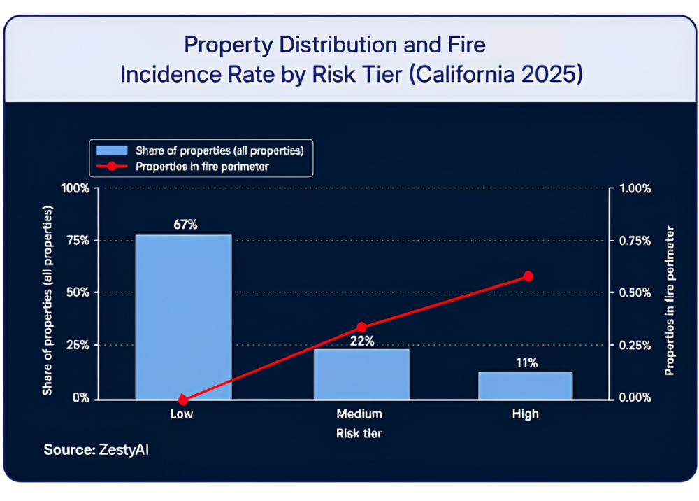
Yet wildfire risk in California is highly concentrated. ZestyAI's analysis of 2025 property data places just 11% of the state's homes in its High Risk wildfire tier, and Z-FIRE had rated 94% of the area burned by the Palisades Fire and 87% of the Eaton burn area High Risk.
Trained on more than 2,000 historical wildfire events, Z-FIRE uses machine learning to evaluate each property's defensible space, vegetation proximity, topography, building materials, and surrounding fire behavior patterns, predicting both the likelihood that a property will encounter wildfire and the vulnerability of the individual structure once exposed. The model is approved across all Western wildfire markets and was the first AI-based wildfire model approved as part of a carrier rate filing in California. ZestyAI's broader portfolio of risk models has secured more than 200 regulatory approvals nationwide.
Attila Toth, Founder and CEO of ZestyAI, said: “For three years, the California story has been about who was leaving. DUAL North America, Kingstone and Windward are writing a different story—each entering the state with a clear, property-by-property view of wildfire risk. That's the kind of precision that lets capacity stay.”
DUAL North America Expands ZestyAI Partnership
Specialty program administrator DUAL North America is using Z-FIRE to assess wildfire exposure at the individual-property level as it builds its California homeowners portfolio.
DUAL first adopted Z-STORM™ in late 2025 to strengthen hail and wind underwriting across its U.S. portfolio. The addition of Z-FIRE expands its use of ZestyAI’s risk models across major catastrophe perils.
Luke Wolmer, Chief Actuary at DUAL, said:
“Launching a California program requires a disciplined, data-driven approach to wildfire risk. Z-FIRE delivers the property-level insight we need to confidently assess exposure, differentiate risk within the same territory, and offer coverage with greater clarity and consistency. That level of precision is essential as we grow our portfolio with greater confidence.”
Kingstone Brings Its Underwriting Strategy to California
Kingstone has selected Z-FIRE as it enters the California homeowners market on an excess and surplus lines basis, marking the company’s first geographic expansion outside the Northeast.
The model will support rating, underwriting and accumulation management as Kingstone scales its California business.
Sarah Minlei Chen, SVP, Chief Actuary and Head of Product Management at Kingstone, said:
“Our California entry reflects the same disciplined, data-driven approach that has driven our results in New York. ZestyAI’s Z-FIRE model complements our Select platform by providing the property-level wildfire intelligence we need to rate and underwrite with precision in a complex and dynamic market like California.”
Windward Risk Managers Extends Partnership into California
Windward Risk Managers is extending its partnership with ZestyAI as it expands from Florida into the California homeowners market.
The company currently uses Z-PROPERTY™ across its Florida portfolio to assess structural and parcel characteristics in a hurricane-exposed market. Windward is now bringing that same property-level approach to California, using Z-FIRE to evaluate wildfire exposure and manage risk at the individual-property level.
Gard Olbers, Chief Risk Officer at Windward Risk Managers, said:
“Z-PROPERTY gave us accurate property insights and broad coverage across our Florida portfolio. That experience made ZestyAI a natural partner as we expand into California, where Z-FIRE gives us an accurate, predictive view of wildfire risk as we evaluate and manage exposure.”

What Spokane 2026 Tells Carriers About Wildfire Exposure
A look at the Spokane Complex fires, what ZestyAI's data shows about wildfire risk scoring, and what's changing for carriers in Washington.
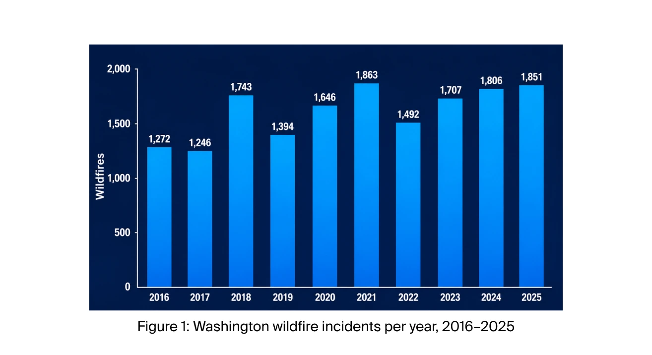
On August 1, 2026, three wind-driven fires converged on the Spokane area in Washington, destroying 833 homes and forcing roughly 65,000 residents to evacuate — a loss that early industry estimates put at $1 to $1.3 billion in insured damage. Washington has averaged about 1,600 wildfires a year for the past decade, but none before the Spokane Complex has destroyed more homes.
For a carrier, an event of this size is a stress test run in real time: claims arrive faster than they can be triaged, policyholders need somewhere to go, and regulators want answers on a timeline the carrier doesn't control. Handling that surge is just the beginning. The harder questions for a carrier are the ones that outlast the headlines: which properties in the book still carry elevated wildfire risk, whether a carrier can tell a homeowner precisely what drove their score, and whether that score moves when the homeowner does the work to earn it, like clearing brush.
What Happened
Wildfire is not new to Washington; most years, it stays in the wildland (Figure 1). These fires didn't. They jumped the wildland-urban interface and burned directly into residential neighborhoods on the edge of the state's second-largest city.
Three fires ignited around Spokane within four hours of each other on Saturday, August 1, 2026: Old Trails on the West Plains, which pushed into neighborhoods on the city's northwest side; Fairview near Mead, to the northeast; and Autumn Lane near Nine Mile Falls, also northwest of the city. All three were driven by the same conditions — winds near 33 mph with gusts above 40, 86-degree heat, and humidity in the low 20s — and together burned about 9,900 acres. Old Trails caused most of the damage.
What Our Data Shows
In June, our 2026 Wildfire Season Preview flagged Washington as a state to watch, with 5.24% of properties identified as high risk.
We compared the fire perimeters against Z-FIRE, ZestyAI's wildfire risk model, which uses machine learning trained on more than 2,000 historical wildfire events. Z-FIRE scores every residential and commercial property in the country from 1 to 10 based on its characteristics and surrounding conditions. Those scores group into five tiers — Very Low, Low, Medium, High, and Very High. And because each property is scored based on its current conditions, the scoring is mitigation-aware: it can reflect actions a policyholder has already taken, like clearing brush or reducing fuels around the home.
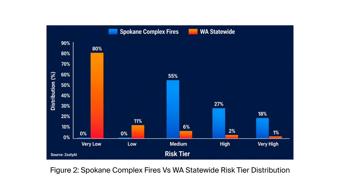
The pattern was clear. Properties scored High or Very High were 14 times more likely than Washington properties overall to fall within the fire perimeters. Very Low and Low properties, about 90% of the state, sat almost entirely outside them; only 0.3% fell within the perimeters (Figure 2).
The same pattern holds outside Spokane. Running the same comparison against the 2025 fire season in neighboring states, we found properties scored High or Very High were 11 times more likely than average to fall within a fire perimeter in Oregon, and 7 times more likely in Idaho.
What Regulators Are Doing
On August 3rd, the Office of the Insurance Commissioner (OIC) issued an emergency order covering all impacted ZIP codes and applying to every property and auto insurer operating in Washington. It runs through September 30, 2026.
The order directs insurers to provide 45-day premium grace periods, waive late and reinstatement fees, and stop cancelling policies for nonpayment unless the policyholder requests it, and it extends the nonrenewal notice period — from 60 to 120 days for property policies, and from 20 to 60 days for auto.
The OIC has also issued a data call for claim counts and losses, though it has not yet published claims totals or an insured-loss estimate.
What Changes for Carriers
The emergency order expires on September 30, but two pieces of legislation will outlast it. Under SSB 5419, a Washington law effective this year, insurers must report every fire loss to the OIC within 90 days of closing the claim, giving the state a running record of where fire losses occur. Senate Bill 5928, still pending, would go further: insurers would have to disclose a homeowner's wildfire risk score, name the factors that drove it, and update it when mitigation work is completed.
Taken together, the direction is clear:
Wildfire risk assessment in Washington is becoming something carriers are expected to explain to the people it affects, not just apply.
What Comes Next
The Spokane Complex will not be the last wildfire to reach the edge of a Washington city, but it offers one clear lesson: the risk was visible, property by property, before the first ignition. Properties a short distance apart can carry very different risk, and a model that sees the difference gives carriers, homeowners, and communities time to act.
Mitigation is where that time pays off. Research shows that reducing fuel around a property can double its likelihood of surviving a wildfire, and a score that identifies its drivers and updates it when the work is done gives homeowners a reason to start. Spokane's recovery is just beginning, and it will take years.
What the rest of Washington can take from these fires is time: the chance to see risk clearly, and to act on it, before the next one.
Amica Deepens ZestyAI Partnership, Extending from Property Risk to Regulatory and Market Intelligence
Amica adopts ZORRO Discover™, ZestyAI's agentic AI platform, to track market filing activity, cut research time by 95%, and accelerate rate and product decisions
Amica Insurance, a leader in auto, home, and life insurance, has expanded its adoption of ZestyAI’s Risk Decision platform with ZORRO Discover™ to gain real-time insight into rate and form filing activity across the insurance market.
The expansion marks the third phase of a partnership that has steadily broadened since 2021. Amica first adopted Z-FIRE™ to assess wildfire risk at the individual-property level. In 2024, the partnership grew to include Z-HAIL™, Z-WIND™, and Z-PROPERTY™, extending that same property-level precision to hail, wind, and structural risk. With ZORRO Discover, Amica now extends the relationship beyond property risk assessment into the regulatory research, competitive benchmarking, and filing workflows that shape rate and product strategy.
ZORRO Discover searches and analyzes millions of P&C rate and form filings — over 200 million pages of regulatory documentation spanning a decade — and returns answers backed by direct citations to the source. Built for insurance, ZORRO’s AI agents understand filing structure and regulatory context, tie answers to carrier market share, and continuously incorporate newly approved submissions, cutting manual research time by 95%. Amica's teams use it to anticipate regulator concerns before submitting, and respond to objections with precedent regulators have already accepted.
Three recent additions extend what the platform can do. Objection Research draws on more than two million filings to show how other carriers answered similar regulator objections and which language was accepted, shortening filing cycles. Watchlist alerts teams the day a carrier they follow files a rate change above a set threshold in any state, line, or filing type they choose. A rate intelligence view consolidates approved rate changes by carrier, state, and line of business into a single screen, with the premium and policyholder impact behind each move.
Lynn Malloney, Vice President, Actuarial State and Product Management at Amica Insurance, said:
“Understanding what is changing in the market—and how regulators are responding—is essential to making sound product decisions. ZORRO Discover gives our teams that context in a fraction of the time, allowing them to focus less on gathering information and more on applying it.”
Attila Toth, Founder and CEO of ZestyAI, said:
"Amica has spent more than a century taking care of its policyholders, and behind that promise are thousands of decisions that have to be right. Our work together began with a single peril model. Today it informs those decisions across perils, across their entire portfolio — and, with ZORRO Discover, across how their teams read the whole market. That kind of expansion only happens when the results earn it.”
ZestyAI has earned more than 200 model approvals across state Departments of Insurance, filing its own AI models and defending them in front of regulators. That track record is why carriers trust ZestyAI with work that has to stand up to regulatory review.
Amica joins a growing number of carriers using ZORRO Discover to modernize regulatory research and support product strategy.

How Do Insurers Use Property-Level Risk Data in Pricing and Underwriting?
P&C Specialist features ZestyAI on how property-level risk data is helping carriers sharpen underwriting and pricing amid rising severe convective storm losses and regulatory scrutiny.
Two neighboring homes can go through the same hailstorm and come away with very different losses. Carriers are increasingly designing around that difference because it shows up directly in results: growth in areas once considered too high-risk (without stepping outside risk appetite or underwriting guidelines), less adverse selection, and sharper segmentation for more accurate underwriting and rating. Regulators have embraced the approach, too: property-level risk models are already being accepted in rate filings across the country. That's the shift detailed in an August 12, 2026 P&C Specialist article by Carl Winfield, with commentary from ZestyAI co-founder and chief product officer Kumar Dhuvur on why property-level risk differentiation is becoming central to how carriers price, underwrite, and grow.
We've tracked this same shift in our own filings research, most recently in The New Competitive Battleground in P&C Insurance.
Why are carriers designing products around property-level risk data?
Because accurate pricing and underwriting depend on seeing risk at the individual property, not the territory average — and that precision is what lets carriers select risks within appetite, avoid adverse selection, and grow with confidence in areas once deemed too high-risk.
Demand for more granular wind risk assessment and hail risk assessment is growing, particularly among Midwest carriers as reinsurers raise the attachment point for severe convective storm coverage and regulators in storm-prone states audit broad ZIP-code-based rate increases instead of approving them by default.
Kumar Dhuvur, ZestyAI's Co-founder and Chief Product Officer, told P&C Specialist:
"Severe convective storm losses have exceeded $50 billion annually for three consecutive years while reinsurance absorbs less of the loss. That makes it essential to demonstrate to regulators why one property represents a materially different risk from another nearby property."
Which states are pushing back hardest on ZIP-code-based rate increases?
Minnesota, Oklahoma and Iowa have actively challenged blanket ZIP-code surcharges. In those three Midwest states, where homeowners rates have surged by double digits over the last several years, regulators have pushed back on carriers relying on ZIP-code-level pricing rather than approving it outright. Illinois went further this month: Gov. JB Pritzker signed legislation ending 50 years of insurers being able to set rates without prior state approval. Across storm corridors, the pattern is consistent — regulators want evidence that a rate reflects the risk of the specific properties it applies to, not just the region.
Regulatory acceptance is also what makes property-level analytics usable inside a filing rather than only in internal analysis: Z-HAIL™, Z-WIND™ and Z-STORM™, ZestyAI's severe convective storm suite, have been accepted in 32 states, and ZestyAI's risk models have secured more than 200 regulatory approvals nationwide.
What variables go into a property-level risk score?
A property-level risk score can account for roof geometry, material and condition, accumulated hail exposure, and localized climatology — evaluated together for how they interact during a severe storm. Carriers are building mathematical formulas around these inputs to produce a score for each individual property, which they submit as supporting evidence in rate filings.
The more precise scores also look beyond a home's standalone characteristics to how a structure interacts with its immediate surroundings — tree density or structural geometry can amplify or reduce wind and hail damage during the same storm event, even between two nearby homes.
Are property-level risk scores used at quote time, or only after a policy is bound?
Increasingly at quote time, before the policy is ever written. Carriers once ordered aerial photos weeks after binding a policy to spot-check a roof; now that same aerial and property data can support new business underwriting during the initial quote, pricing roof hazards before a policy is ever written rather than catching issues after the fact. The same property intelligence can also support renewal decisions as conditions change over time.
Are percentage deductibles and ACV roof schedules rising?
Yes. Both have grown sharply over the same decade property-level data has become more available.
A ZestyAI audit of more than 2,000 filings between 2015 and 2025 found that adoption of actual-cash-value roof settlement schedules surged from 10% to 60% among the top 10 homeowners carriers, while mandatory percentage wind and hail deductibles grew from 60% to 90% over the same period. Coverage architecture is doing on the claims side what property-level data is doing on the rate side: giving carriers a more granular way to match terms to actual risk. The important shift is not simply toward more restrictions; it is toward making those decisions more closely reflect the underlying risk, so carriers do not end up penalizing good risks while retaining the properties that are actually driving losses.
How does parcel-level pricing change the relationship between carriers, agents and policyholders?
Property-level pricing moves the conversation from territory-level generalities to the risk factors of one specific address. That actuarial precision changes the dynamic industry-wide: an agent can no longer explain a quote by pointing to a rating territory alone, because two nearby policyholders can now be priced very differently based on their own property's characteristics rather than the neighborhood they share.
It also changes what a policyholder can do about their rate. ZestyAI's severe convective storm models are mitigation-aware: verified improvements such as a roof replacement, an upgrade to more impact-resistant roofing material, or corrected property data can be reflected directly in the risk score. That gives carriers a clearer way to show not only why two nearby properties are priced differently, but how specific actions can reduce that risk.
Is territory-based rating still viable alongside property-level scoring?
Yes, but risk varies more within a single territory than a territory-level rating factor can capture.
Roof shape and geometry, features like vents and skylights, material and age all affect a property's susceptibility to storm damage, Dhuvur said.
"Two neighboring homes can experience the same hail event and still have very different loss outcomes."
Modeling the interaction between the structure and localized climatology is what produces real separation between good and bad risks within the same territory — segmentation a territory factor alone cannot see. For carriers, that means competitve and internal benchmarking has to move to the same parcel-level granularity rather than staying anchored to territory averages.
How can carriers benchmark their own rate filings against competitors?
By reviewing the risk models and coverage language competitors have already gotten approved in the same states, rather than starting from a blanket rate ask. As property-level scoring becomes table stakes in catastrophe-exposed states, the carriers with the most defensible filings are the ones who can show regulators exactly how a property's risk score was derived — and how it compares to similar filings already accepted in that state.
ZORRO Discover gives filing and product teams that reference point: competitor risk models, coverage language and adoption rates cited in approved filings, so a new filing can be built on evidence regulators have already accepted.
Read the full article: Insurers Turn to Property-Level Risk Models to Justify Rate Increases → P&C Specialist, August 12, 2026, by Carl Winfield. Includes commentary from ZestyAI Co-founder and Chief Product Officer Kumar Dhuvur.
.png)
Regulators in More Than 20 States Accept ZestyAI's Z-WATER as Insurers Confront $15B Non-Weather Water Problem
The approvals clear the way for carriers to price non-weather water risk at the individual property level, with 18x sharper risk segmentation than traditional territory- and age-based methods.
ZestyAI's Z-WATER™, its property-level model for non-weather water risk, has been accepted for use in carrier rate and rule filings in more than 20 states nationwide. Nevada, Oregon, Ohio, South Carolina, and Oklahoma are among the model’s recent state approvals.
Non-weather water has become the fourth-costliest peril in homeowners insurance, driving more than $15 billion in annual losses across more than one million claims. Claim severity has also risen 80%, compounding the financial impact for insurers as even routine water incidents become increasingly costly. Unlike weather catastrophes, these losses often begin with ordinary failures inside the home — a burst pipe, plumbing deterioration, appliance failure, or hidden leak — but can result in significant damage before they are detected.
Despite the scale of the problem, insurers have historically had limited ways to distinguish which individual properties are most susceptible to water losses. Traditional approaches often rely on broad geographic territories, property age, and other proxies that can overlook meaningful differences between otherwise similar homes.
Z-WATER addresses that gap by evaluating risk at the individual-property level. Trained and validated using insurer loss data, the model uses computer vision to read aerial imagery and evaluates how property characteristics, permitting history, localized climatology, and infrastructure context interact to drive both the frequency and severity of non-weather water claims. Z-AWATER delivers 18x risk segmentation lift compared with traditional territory- and age-based approaches, giving insurers a far sharper read on risk across their portfolios.
"Non-weather water losses place real pressure on carriers' books, but they're also highly preventable when you understand where the risks actually lie," said Bryan Rehor, Senior Director of Regulatory and Government Affairs at ZestyAI.
"The growing regulatory acceptance of Z-WATER reflects a broader shift toward models that can identify meaningful differences in risk from one home to the next while providing the transparency regulators expect.”
The expansion of Z-WATER builds on ZestyAI’s broader regulatory momentum. Across its models for wildfire, hail, wind, severe convective storm, non-weather water, and property and roof intelligence, ZestyAI has secured more than 200 regulatory approvals nationwide.
As insurers confront rising property loss costs, carrier adoption and regulatory acceptance of property-specific risk models are advancing in parallel, giving insurers new ways to move beyond broad geographic and age-based proxies and more accurately reflect the risk of individual properties.
Ready to see how ZestyAI works on your book of business?
Tell us a little about your needs. We'll show you how we reduce losses and help you price with precision.