Reports & Research
Explore proprietary research packed with data, insights, and real-world findings to help carriers make smarter decisions.
.png)
ZestyAI Publishes Data-Driven Look at 2022 Wildfire Season
2022 Wildfire Season Overview looks back at 2021 and ahead to what may be a long year of wildfires in 2022.
Today, ZestyAI released its 2022 Wildfire Season Overview. Each year, ZestyAI prepares a comprehensive overview to help guide insurers based on recent wildfire events, persistent drought conditions, and advancements in artificial intelligence for managing wildfire risk.
If it seems like wildfires are burning at all times of the year, it's not just you. Very destructive events, like last December's Marshall Fire, are occurring in months not typically associated with high wildfire danger. Those who study wildfires, including ZestyAI, have begun to start thinking in wildfire "years" instead of wildfire "seasons'. Strong wildfire years, with 10+ million acres burned, have quickly become the new normal. The last 10 years have been the worst on record for property and casualty (P&C) insurers when it comes to wildfire. 8 of the top 20 fires in California history, and more than half of the acreage burned by them, occurred in just the years 2020 and 2021.
What can insurers do to prepare themselves for persistent wildfires?
- Understand the Data: Instead of sticking with decades-old approaches, assess wildfire risk at the property level.
- Continue to Bring Transparency and Education to Homeowners: Insights from AI-based wildfire risk models may be passed on to homeowners and agents, enabling a much better understanding of wildfire risk.
- Find the Right Technology Partner: Aerial and satellite imagery, machine learning, and infinitely scalable cloud computing resources were combined to build the most granular wildfire risk assessment model (Z-FIRE™). Using Z-FIRE™, ZestyAI can accurately estimate an individual property’s wildfire risk, plus highlight the key property-level factors that contribute to that risk.
Click here to download ZestyAI's 2022 Wildfire Season Overview.
ZestyAI offers insurers and real estate companies access to precise intelligence about every property in North America. The company uses AI, including computer vision, to build a digital twin for every building in North America, encompassing 200B property insights accounting for all details that could impact a property’s value and associated risks, including the potential impact of natural disasters. Visit https://zesty.ai for more information.
The 2021 Wildfire Season has Devastating Potential
A Data-Driven Conversation about the US West’s Megadrought
Current climate conditions in the West reveal that 2021 may have a higher than normal risk for wildfire losses. While much of this report focuses on California, historically the worst victim of wildfire in the US, the entire western US is of concern in 2021. In particular, the expansion of deep drought into Colorado is of major concern.
Drought is a leading factor in seasonal wildfire risk. With drought extending through every western state this spring, insurers should consider looking deeply into how they are addressing this growing peril. According to AON, last year’s wildfires in the US West cost insurers over $8 billion.
We've released a complete detailing the devastating potential for 2021's wildfire season. The full report is available here.
Nearly Doubling a Property’s Wildfire Survival Rate: New Study from ZestyAI in Collaboration with IBHS Shows Impact of Key Mitigation Action
Research across more than 71,000 properties involved in wildfires draws significant links between fuel management and property survival.
Oakland,Calif., April 8, 2021: ZestyAI, a leader in climate risk analytics powered by Artificial Intelligence (AI), and the Insurance Institute for Business & Home Safety (IBHS) today released new research on how fuel management impacts destruction rates from wildfires. They found property owners who clear vegetation from the perimeter of their home or building can nearly double their structure's likelihood of surviving a wildfire.
ZestyAI, in conjunction with, IBHS studied more than 71,000 properties involved in wildfires between 2016 and 2019 to assess the relationship between vegetation, buildings, and property vulnerability. To do this, ZestyAI leveraged a combination of computer vision and AI to analyze high resolution satellite and aerial imagery of the properties that fell within the wildfire perimeter, which allowed them to determine what effects a property's physical environment had on its likelihood of survival. They found buildings with a high amount of vegetation within 5 feet of the structure were destroyed in a wildfire 78 percent of the time -- a rate nearly twice as high as those with small amounts of perimeter vegetation. This pattern held true as ZestyAI analyzed the other defensible zones, ranging from 30 to 100 feet around the property.
"It's common sense that increased vegetation increases wildfire risk, but this study shows just how powerful individual action can be in safeguarding structures. Mitigation actions that can cut risk nearly in half are statistically meaningful to anyone with a stake in this peril," said Attila Toth, CEO of ZestyAI. "These findings also underscore how wildfire research at IBHS and artificial intelligence at ZestyAI translates to real-world impact at the intersection of homeowners, community leaders, regulators, and insurance carriers. This type of collective action will help protect our communities from the devastating impact of wildfire, which unfortunately has continued to increase over the last decade."
The study also supported and confirmed takeaways from IBHS's Suburban Wildfire Adaptation Roadmaps released last year, which go beyond the home ignition zone to detail additional actions needed across eight aspects of a home to address a home's wildfire vulnerability. ZestyAI's new research found that having other structures in close proximity to a property increases its wildfire risk, particularly for properties in areas with moderate to high vegetation coverage. Buildings in these areas that had another structure within 30 to 100 feet from the property were destroyed in a wildfire 60 percent of the time, compared to a 31 percent destruction rate for homes without another structure in close proximity.
"This research further demonstrates to homeowners, community leaders, and policy makers just how impactful taking the mitigation actions laid out in the Suburban Wildfire Adaptation Roadmaps can be in protecting homes from wildfire ignition," said Roy E. Wright, President & Chief Executive Officer at IBHS. "Quantifying the effect of mitigating fuel density risk, one of the critical actions identified in the Roadmaps, is a first piece in the larger puzzle of what groups of mitigation actions most improve the chance of home survival and by what level."
ZestyAI is uniquely equipped to support this type of research because of the proprietary wildfire property loss database it developed for Z-FIRE™, its AI model that generates property-specific predictive risk scores. Z-FIRE™ has been trained on more than 1,200 wildfire events across several decades and accounts for the property-level factors that contribute to wildfire risk, including defensible space, building material, and roof pitch, which legacy models fail to consider.
Wright added, "While it is not possible to eliminate wildfire risk we are not powerless against it. We must take a pragmatic approach to mitigate risk at all levels and ultimately reduce property damage through data and science. Through collaborations with modelling organizations like ZestyAI, advanced technology like computer vision and AI help us better understand the impact of these actions at a larger scale. It is encouraging to see emerging progress in just the first months of 2021."
For additional insights you can read the full research paper, ‘Wildfire Fuel Management and Risk Mitigation - Where to Start?' here. For more information on ZestyAI please visit www.zesty.ai, and for more information on IBHS please visit www.ibhs.org.
About ZestyAI (www.zesty.ai): Increasingly frequent natural disasters, such as wildfires, floods and hurricanes devastated communities and drove $2.2 Trillion in economic losses over the past decade. ZestyAI uses 200Bn data points, including aerial imagery, and artificial intelligence to assess the impact of climate change one building at a time. ZestyAI has partnered with leading insurance companies and property owners helping them protect homes, businesses and support thriving communities. ZestyAI was named Top 100 Most Innovative AI Company in the world by CB Insights in 2020, and Gartner Cool Vendor in Insurance by Gartner Research in 2019. For more information visit: https://www.zesty.ai/
About the Insurance Institute for Business & Home Safety (IBHS)
The IBHS mission is to conduct objective, scientific research to identify and promote effective actions that strengthen homes, businesses and communities against natural disasters and other causes of loss. Learn more about IBHS at DisasterSafety.org.
ZestyAI Research: Up to $9.8Bn in Losses Already Caused by Wildfires in 2020
As of September 18th, between $5.9Bn and $9.8Bn in losses have occurred this year alone.
The Zest
ZestyAI has been keeping a close eye on the wildfires burning in the Western United States. Whether by evacuation or smoke, most of our employees have felt the impact firsthand.
Utilizing our vast wildfire data and artificial intelligence resources, we have estimated that as of September 18th, between $5.9Bn and $9.8Bn in losses have occurred this year alone.
What has made 2020 unique?
Two key aspects have made the 2020 Wildfire Season exceptional: the number of acres burned and the timing of the fires.
2018, which previously held the California record for acres burned at 1,975,086 has been eclipsed with months left in the seasons. More than 3.3 million acres have already been charred by wildfire this year in California alone, and more than 5 million in the Western US.
Fire season tends to start in September and peak in November. In August, a large scale lightning event occurred, triggering many of the California wildfires. Oregon, which typically has a shorter wildfire season has also seen early and widespread wildfires.
Analysis Methodology
Using ZestyAI’s comprehensive historical wildfire loss data, up-to-date wildfire perimeter locations for the 2020 season, residential and commercial property information, and fueled by ZestyAI’s AI-driven wildfire damage risk scores, the expected destruction and cost of the 2020 wildfire season so far was calculated for California, Oregon, and Washington.
To estimate the destruction and damages, ZestyAI identified every structure involved in the 2020 wildfire perimeters and their associated wildfire vulnerabilities. Using the historical relationship between the risk profile of the structure, asset value, and economic loss, ZestyAI was able to estimate the full economic loss of those events (including non-insured assets such as uninsured property, and non-insured economic cost). Actual information from CalFire on CZU and LNU incident was used to validate the methodology.
From our extensive historical loss data, a relationship between structural damage expected and the cost of wildfire events was developed based on local property and loss information and expanded to include additional considerations such as smoke damage, displacement costs, and construction.
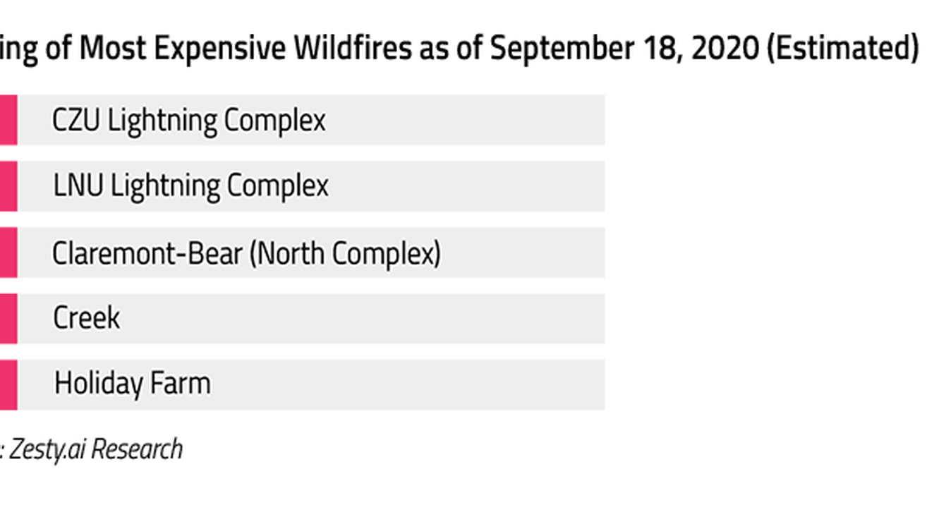
The 5 Most Destructive Fires So Far
Our estimates place the Claremont-Bear (North Complex) at the top of the list of most destructive in terms of number of properties lost. Four of these five wildfires occurred in California with the Alameda Drive fire occurring in Oregon.

The 5 Most Expensive Fires So Far
While the Claremont-Bear (North Complex) fire is estimated to have destroyed the most properties, the CZU Lightning Complex fire is currently estimated to be the most costly at up to $2.6B. That makes it responsible for ~27% of all total economic losses from fires in the 2020 season so far.
Putting Numbers on Destruction
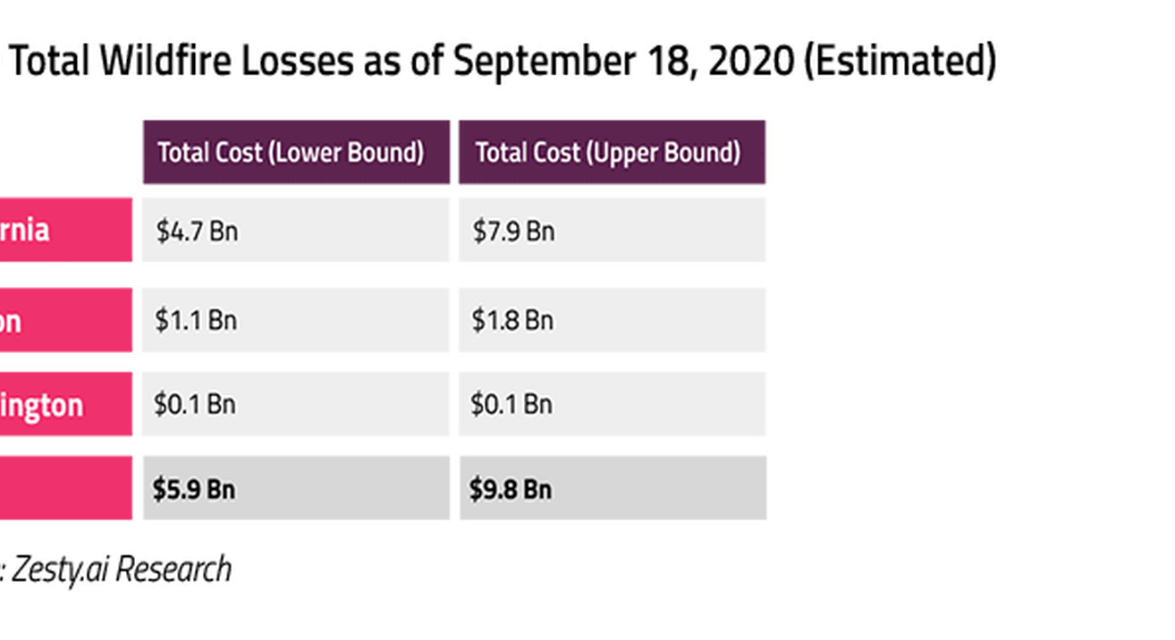
By ZestyAI estimates, between $5.9Bn and $9.8Bn of economic losses have occurred in California, Oregon, and Washington so far this year. California, which also leads in acres burned (5M+) makes up the lion’s share at up to $7.9B.
It’s important to state that the fire season is not yet over. In much of the Western US, it could be just beginning. With a number of fires still active and the potential for more to start, these numbers are almost certain to rise between now and the end of the year.
Looking Forward
Multiple estimates place the 2018 wildfire season at around $15Bn in total losses. While exceptional in terms of total acres burned, the 2020 wildfire season has not yet reached that level of economic loss. Without any doubt, this will be one of the costliest years on record, and with months left in the season, the potential exists for this year to surpass 2018 if it continues at its current pace.
ZestyAI will continue to monitor this fire season. As in years past, new data continues to refine our models and analyses. Insurance professionals and media who would like more information about this analysis or about how artificial intelligence can help insurers protect themselves and their customers from wildfire should contact us.
AI-Powered Severe Convective Storm Risk Models Approved in Ohio
Amid a surge in billion-dollar storm events, Ohio insurers gain access to advanced, property-specific risk models that strengthen underwriting.
ZestyAI announced that its Severe Convective Storm suite, including Z-HAIL™, Z-WIND™, and Z-STORM™, has received regulatory approval from the Ohio Department of Insurance.
With the addition of Ohio, ZestyAI’s Severe Convective Storm suite is now approved for use in 16 states, covering key high-risk markets across the Midwest, Great Plains, and South.
Ohio Faces Rapidly Rising Storm Losses
Ohio has experienced 36 billion-dollar loss storm events over the past five years alone, surpassing the total from the previous two decades, which saw just 33 events, according to NOAA’s National Centers for Environmental Information (NCEI). Severe convective storms, including hail, wind, and tornadoes, were the driver, contributing to over 57% of the state’s total weather-related damages since 1980.
Traditional Models Miss Critical Property-Level Differences
ZestyAI’s AI-driven platform predicts the likelihood and severity of claims from severe convective storms at the individual property level by analyzing the interaction of local climatology with property-specific characteristics. In contrast, most risk assessment models today rely on broader territory or ZIP code-level evaluations, overlooking critical property-level factors.
Each model is built and validated on extensive real-world claims data and delivers transparent explanations of the key drivers behind every risk score, helping carriers make more accurate underwriting and rating decisions.
Key capabilities include:
- Z-HAIL: Predicts hail damage risk and claim severity using property-specific attributes like roof complexity, historical losses, and accumulated damage, identifying which homes are most likely to file a claim, even within the same neighborhood.
- Z-WIND: Combines AI-generated 3D analysis of roof condition, complexity, and potential failure points with local climatology to deliver pivotal insights into property-specific wind vulnerability and severity.
- Z-STORM: Predicts the frequency and severity of storm damage claims, examining the interaction between climatology and the unique characteristics of every structure and roof.
Regulatory Approval Reflects a Shift Toward Precision Underwriting
“Too often, storm risk is priced using rough proxies instead of accurate property insights,” said Kumar Dhuvur, Founder and Chief Product Officer at ZestyAI.
“Regulatory approval in Ohio affirms the industry’s shift toward precision underwriting and rating—and opens the door to smarter, risk-aligned decisions and fewer preventable losses in one of the nation’s most important insurance markets.
12.6 million US properties at high risk from hail damage
ZestyAI analysis reveals $189.5 billion in potential hail losses.
ZestyAI's analysis revealed that more than 12.6 million U.S. properties are at high risk of hail-related roof damage, representing $189.5 billion in potential replacement costs.
Powered by ZestyAI’s Z-HAIL™ model, the analysis underscores the growing financial threat of severe convective storms (SCS), including hail, tornadoes, and wind events. In 2024 alone, damages from SCS were estimated at $56 billion—surpassing losses from hurricanes.
Yet many insurers still rely on traditional models designed to estimate portfolio-level exposure, not property-level risk. As hail events increase in severity and frequency, these models often miss the structural and environmental conditions that drive real losses.
Kumar Dhuvur, Co-Founder and Chief Product Officer at ZestyAI said:
“Catastrophe models have helped insurers understand where storms may strike and how losses might add up at a portfolio level. But they weren’t built to assess risk at the individual property level, and they often miss the specific conditions that drive hail damage. By analyzing the interaction between structure-specific features and local storm patterns, we can distinguish risk between neighboring properties—enabling smarter underwriting, more precise pricing, and better protection for policyholders.”
Z-HAIL evaluates hail risk using a proprietary blend of climate, aerial, and property-specific data. By applying advanced machine learning to these inputs, Z-HAIL delivers highly granular predictions that reflect both the physical characteristics of a structure and the storm activity in its immediate surroundings.
Key findings from the analysis:
- 12.6 million U.S. structures flagged as high risk for hail-related roof damage
- $189.5 billion in total potential roof replacement exposure
Top five states by dollar exposure:
- Texas ($68B)
- Colorado ($16.7B)
- Illinois ($10.8B)
- North Carolina ($10.4B)
- Missouri ($9.5B)
States with the lowest dollar exposure:
- Maine ($4.7M)
- Idaho ($12.8M)
- New Hampshire ($18.5M)
- Nevada ($49.3M)
- Vermont ($64.7M)
In recent case studies, Z-HAIL has demonstrated the ability to pinpoint which properties are most susceptible to hail damage—even within the same neighborhood and exposed to the same storm. In one example from Allen, Texas, following a storm with 2.5-inch hailstones, Z-HAIL segmented risk across 483 policies, identifying no losses among properties rated “Very Low” by the model. This level of intra-territory precision gives insurers the ability to refine risk selection with confidence—even in the most hail-prone regions of the country.
-1.png)
Unlocking Insurance Access for Half a Million Homes and Business Owners
ZestyAI's property-level risk models are helping insurers expand sustainable coverage in wildfire- and storm-prone regions.
ZestyAI helped carriers and insurers of last resort extend coverage to over 511,000 properties previously deemed uninsurable in 2024. This year, ZestyAI aims to double its impact, helping to bring coverage options to over a million families and businesses, ensuring that those in catastrophe-prone regions have access to sustainable, risk-aligned insurance.
A 2024 Deloitte survey found that nearly a quarter of homeowners in high-risk states are struggling to find coverage, while over half cite affordability as a growing concern—underscoring the industry’s need for granular insights that support underwriting and pricing decisions aligned with true property-level risk.
“For too long, insurers have had to make high-stakes decisions with incomplete information,” said Attila Toth, Founder and CEO of ZestyAI. “Advanced AI models are changing that. With granular, property-specific risk insights, insurers can close protection gaps and build a more resilient market.”
Traditional risk assessment methods rely on territory- or ZIP code-level evaluations, overlooking the property-level characteristics that drive risk. This approach leads to adverse selection, inaccurate pricing, and widespread market withdrawal.
ZestyAI replaces this approach with transparent, AI-powered models that integrate climatology, geospatial data, historical losses and structural attributes to deliver precise views of wildfire, hail, and wind risk, among other perils.
The results:
- Clear mitigation guidance to help policyholders take action.
- Risk-aligned premiums that support responsible market expansion.
- Improved underwriting precision through AI-driven risk scores and near-complete U.S. coverage.
- Optimized loss cost controls via more effective deductible, Actual Cash Value (ACV), and coverage strategies.
- A supportive experience for carriers, families, and businesses—enabling faster decisions, better communication, and greater confidence in coverage options.
- Streamlined inspections that lower expenses and improve efficiency.
ZestyAI collaborates closely with regulators to ensure transparency, validation, and model oversight. Its wildfire model, Z-FIRE, is approved across all Western states, while its severe convective storm models have gained broad acceptance from Texas to Colorado and throughout the Midwest and Great Plains.
As regulators support the use of advanced models, they are also paving the way for smarter risk-based pricing and proactive mitigation—revitalizing insurance’s core mission: protecting the livelihood of home and business owners and their communities.
.png)
2025 Storm Risk Webinar Now Available On Demand
Stream our webinar for a preview of severe convective storm risk in 2025 and see how AI-driven insights can help you stay prepared.
Severe convective storms are becoming more frequent and costly, putting pressure on insurers to refine underwriting and risk management strategies.
On April 2, our experts covered:
- Key drivers behind increasing severe storm losses
- What La Niña means for the 2025 season
- How AI-powered risk models improve risk segmentation
- Live Q&A – Get expert answers to your toughest questions!
Missed the live event? Stream now!
EarthDaily Analytics Partners with ZestyAI for Advanced Property Risk Insights
Earth Observation data meets AI to address rising climate risks and enhance insurance decision-making.
ZestyAI has partnered with EarthDaily Analytics (EarthDaily), a global provider of Earth Observation analytics and data.
Through this partnership, ZestyAI’s advanced models—including Z-FIRE™, Z-HAIL™, Z-WIND™, and Z-STORM™—will be available through EarthDaily’s Ascend platform, delivering geospatial data, risk modeling, and post-event insights to insurers.
With the insurance industry facing escalating challenges from climate-driven catastrophes and increasing pressure to accurately price risk, ZestyAI’s models provide granular, property-level risk data. These models analyze factors like vegetation density, construction materials, and historical weather patterns to offer insights beyond traditional methods.
“At EarthDaily, we’re committed to delivering cutting-edge property insights to customers navigating today’s climate risks,” said Rachel Olney, VP of Insurance at EarthDaily.
With advanced AI models covering wildfire, hail, wind, and property data, ZestyAI is an ideal partner to support our mission.
"By including their advanced analytics in our Ascend platform, we’re excited to empower clients to take proactive steps in managing and mitigating risk with confidence."
ZestyAI’s solutions achieve nearly 100% hit rates, offering actionable insights that insurers and businesses can trust. By bolstering the data available in the Ascend platform with property-level insights, the partnership provides decision-makers with a new level of clarity to mitigate risks, improve underwriting, and allocate resources more effectively.
The collaboration exemplifies the growing importance of innovative technology in the insurance and property management sectors, especially as global climate risks continue to evolve.
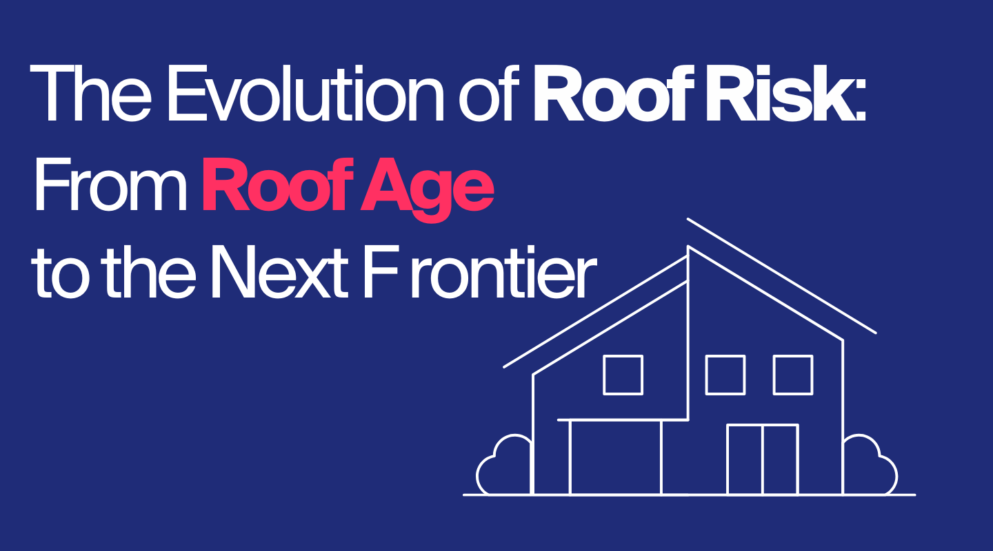
Roof Age in Rate Filings is Down: What’s Taking Its Place?
For the first time in two decades, regulatory filings using Roof Age have declined as a new standard emerges.
For years, insurers asked:
“How old is this roof?”
Now, the real question is:
“How will this roof perform?"
The way insurers assess roof risk has evolved significantly over the past two decades. What began as a simple Roof Age-based surcharge has transformed into a sophisticated approach that considers real-time condition, storm resilience, and structural complexity.
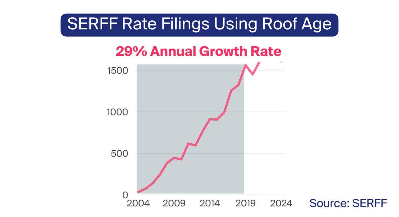
A closer look at SERFF regulatory filings traces the first recorded use of Roof Age back to 2004 when The Hartford introduced Roof Age-based pricing in Iowa.
At the time, the insurer applied a flat 10% surcharge to roofs 26 years and older—a figure that now seems outdated, as many carriers won’t insure roofs older than 15 years.
Roof Age quickly became a key rating factor—by the 2010s, Roof Age adoption in rate filings surged, growing at an annual rate of 29%.
If you fast forward just 10 years after The Hartford’s initial filing, you’ll find a stark contrast in how roof risk was assessed. By 2014, The Hartford’s rate filing in Iowa contained 51 pages of actuarial tables, detailing various roof materials and rate adjustment factors for age.
This shift reflected a broader trend—Roof Age moved from a simple surcharge to a more nuanced risk model that accounted for material durability, wear patterns, and structural longevity.
By 2018, insurers began looking beyond Roof Age, and that’s when Roof Condition first appeared in regulatory filings.
Over the past five years, its adoption has surged 32% annually, outpacing Roof Age at its peak. Insurers also began incorporating roof complexity variables, such as pitch and facets, to further refine their risk assessment models.
These advancements provided a more nuanced view of risk, moving beyond the assumption that all old roofs posed the same level of hazard.
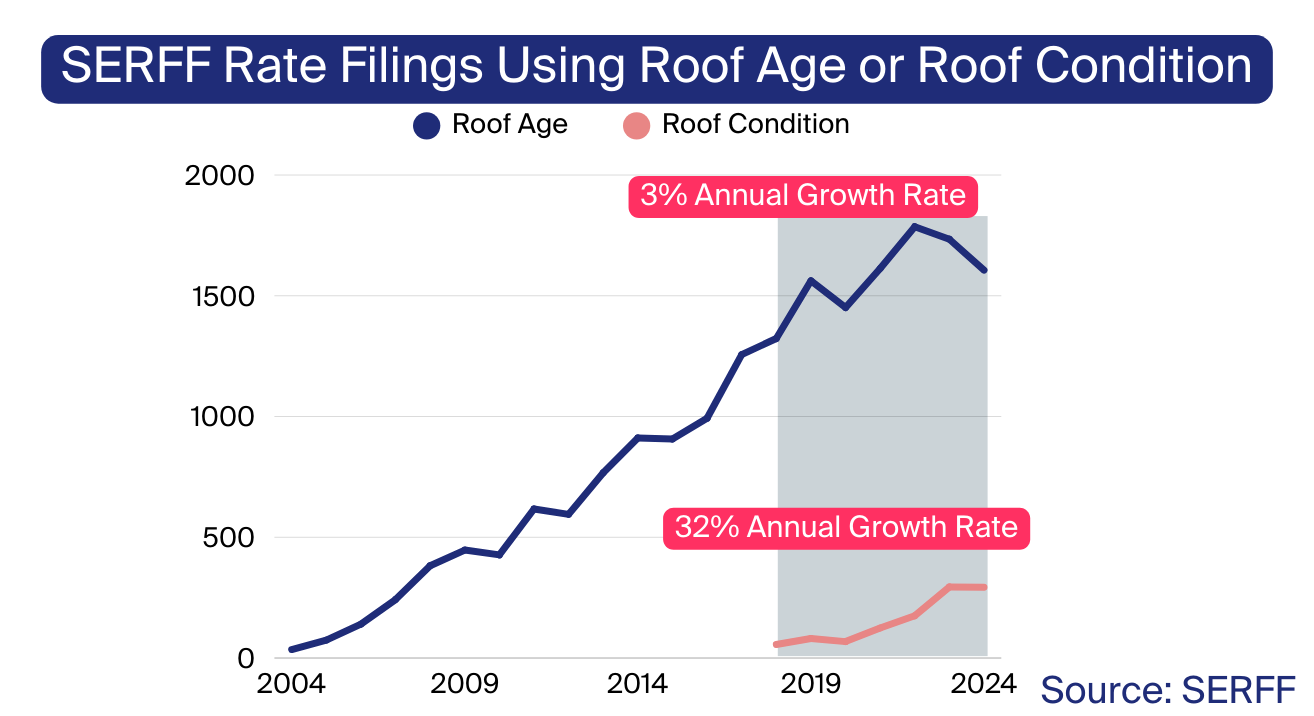
Now, for the first time in two decades, Roof Age is plateauing. Over the past two consecutive years, we've seen a decline in the number of filings incorporating Roof Age, bringing its usage close to 2019 levels.
This decline suggests that carriers are moving toward more sophisticated approaches, leveraging real-time condition assessments rather than relying solely on the number of years since installation. After all, a 10-year-old roof in poor condition can present a greater risk than a 20-year-old roof that has been well-maintained—and insurers are recognizing the importance of capturing these distinctions.
With severe convective storm-related insured losses reaching $58 billion in 2024, traditional risk assessment methods can no longer keep up.
A new paradigm is emerging, where advanced AI-driven risk models provide the precision and resilience needed to navigate an increasingly volatile climate.
At ZestyAI, we’re helping insurers make this shift with models like Z-STORM, Z-HAIL, and Z-WIND, which are already filed and approved in 14 states, including Texas, Colorado, Illinois, Oklahoma, and Louisiana.
Those who embrace these innovations will gain a competitive edge—reducing loss costs, improving operational efficiency, and ultimately shaping the future of risk assessment in property insurance.

See How Insights Turn Into Decisions
ZestyAI transforms data into action. Get a demo to see how the same AI powering our reports helps carriers make faster, smarter, regulator-ready decisions.