
What Spokane 2026 Tells Carriers About Wildfire Exposure
A look at the Spokane Complex fires, what ZestyAI's data shows about wildfire risk scoring, and what's changing for carriers in Washington.

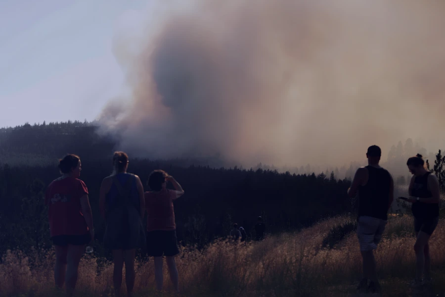
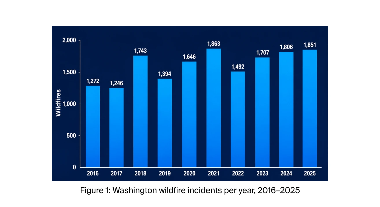
On August 1, 2026, three wind-driven fires converged on the Spokane area in Washington, destroying 833 homes and forcing roughly 65,000 residents to evacuate — a loss that early industry estimates put at $1 to $1.3 billion in insured damage. Washington has averaged about 1,600 wildfires a year for the past decade, but none before the Spokane Complex has destroyed more homes.
For a carrier, an event of this size is a stress test run in real time: claims arrive faster than they can be triaged, policyholders need somewhere to go, and regulators want answers on a timeline the carrier doesn't control. Handling that surge is just the beginning. The harder questions for a carrier are the ones that outlast the headlines: which properties in the book still carry elevated wildfire risk, whether a carrier can tell a homeowner precisely what drove their score, and whether that score moves when the homeowner does the work to earn it, like clearing brush.
What Happened
Wildfire is not new to Washington; most years, it stays in the wildland (Figure 1). These fires didn't. They jumped the wildland-urban interface and burned directly into residential neighborhoods on the edge of the state's second-largest city.
Three fires ignited around Spokane within four hours of each other on Saturday, August 1, 2026: Old Trails on the West Plains, which pushed into neighborhoods on the city's northwest side; Fairview near Mead, to the northeast; and Autumn Lane near Nine Mile Falls, also northwest of the city. All three were driven by the same conditions — winds near 33 mph with gusts above 40, 86-degree heat, and humidity in the low 20s — and together burned about 9,900 acres. Old Trails caused most of the damage.
What Our Data Shows
In June, our 2026 Wildfire Season Preview flagged Washington as a state to watch, with 5.24% of properties identified as high risk.
We compared the fire perimeters against Z-FIRE, ZestyAI's wildfire risk model, which uses machine learning trained on more than 2,000 historical wildfire events. Z-FIRE scores every residential and commercial property in the country from 1 to 10 based on its characteristics and surrounding conditions. Those scores group into five tiers — Very Low, Low, Medium, High, and Very High. And because each property is scored based on its current conditions, the scoring is mitigation-aware: it can reflect actions a policyholder has already taken, like clearing brush or reducing fuels around the home.
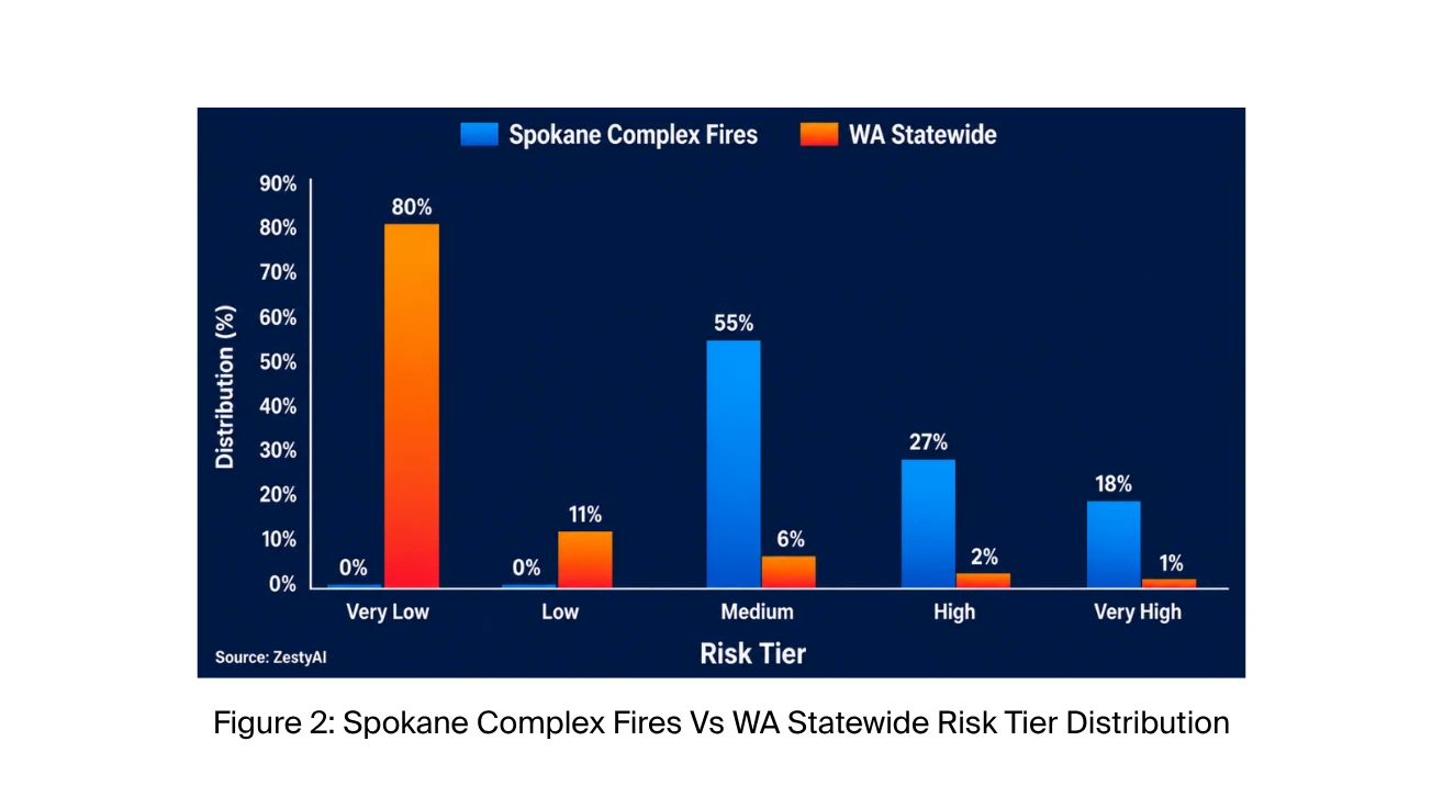
The pattern was clear. Properties scored High or Very High were 14 times more likely than Washington properties overall to fall within the fire perimeters. Very Low and Low properties, about 90% of the state, sat almost entirely outside them; only 0.3% fell within the perimeters (Figure 2).
The same pattern holds outside Spokane. Running the same comparison against the 2025 fire season in neighboring states, we found properties scored High or Very High were 11 times more likely than average to fall within a fire perimeter in Oregon, and 7 times more likely in Idaho.
What Regulators Are Doing
On August 3rd, the Office of the Insurance Commissioner (OIC) issued an emergency order covering all impacted ZIP codes and applying to every property and auto insurer operating in Washington. It runs through September 30, 2026.
The order directs insurers to provide 45-day premium grace periods, waive late and reinstatement fees, and stop cancelling policies for nonpayment unless the policyholder requests it, and it extends the nonrenewal notice period — from 60 to 120 days for property policies, and from 20 to 60 days for auto.
The OIC has also issued a data call for claim counts and losses, though it has not yet published claims totals or an insured-loss estimate.
What Changes for Carriers
The emergency order expires on September 30, but two pieces of legislation will outlast it. Under SSB 5419, a Washington law effective this year, insurers must report every fire loss to the OIC within 90 days of closing the claim, giving the state a running record of where fire losses occur. Senate Bill 5928, still pending, would go further: insurers would have to disclose a homeowner's wildfire risk score, name the factors that drove it, and update it when mitigation work is completed.
Taken together, the direction is clear:
Wildfire risk assessment in Washington is becoming something carriers are expected to explain to the people it affects, not just apply.
What Comes Next
The Spokane Complex will not be the last wildfire to reach the edge of a Washington city, but it offers one clear lesson: the risk was visible, property by property, before the first ignition. Properties a short distance apart can carry very different risk, and a model that sees the difference gives carriers, homeowners, and communities time to act.
Mitigation is where that time pays off. Research shows that reducing fuel around a property can double its likelihood of surviving a wildfire, and a score that identifies its drivers and updates it when the work is done gives homeowners a reason to start. Spokane's recovery is just beginning, and it will take years.
What the rest of Washington can take from these fires is time: the chance to see risk clearly, and to act on it, before the next one.